Glen Innes to Tamaki Drive Shared Path

Auckland Transport (AT) and the NZ Transport Agency are creating a shared path for cyclists and pedestrians from Merton Road near Glen Innes Station to Tamaki Drive – allowing you to walk, run or cycle from Auckland’s eastern suburbs to the Waitematā Harbour. More information here: https://at.govt.nz/projects-roadworks/glen-innes-to-tamaki-drive-shared-path/

Eastern Path Updates – September 2015

24 September 2015

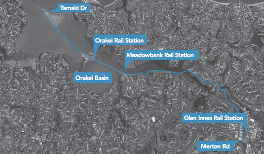
It’s all go for the Eastern Path! This is a pathway which will eventually link Glen Innes with Tamaki Drive via a shared walkway/cycleway through the Pourewa Valley. Recent updates indicate the official start date for Section 1 (Glen Innes – St Johns Rd section) will be on October 19, and Auckland Transport has promised more links into the pathway for Meadowbank & St Johns residents.

Tamaki Drive to Glen Innes shared walkway map

Email from Auckland Transport

We received an email from Aaron Hutching – the Public Affairs Advisor from Auckland Transport – on September 9. The full email is below, but key points are:

  • Section 1 (Merton Rd – St Johns Rd) expected to begin in October 2015
  • Feedback indicated that more connections to the pathway are required, particularly in Section 2 (Meadowbank & St Johns section between St Johns Rd and Meadowbank Station)
  • Auckland Transport will showcase potential designs (with linkages into the pathway from surrounding areas) for Section 2 at a public open day to be held later this year.

Notes from Stakeholder Meeting

Our Transport Subcommittee Co-chair Carmel Claridge attended at Stakeholder Meeting on September 21. Key points from this meeting include:

  • Official start date for Section 1: October 19, subject to consents but anticipated to be no delay
  • Ongoing consultation for links from Glen Innes into Section 1
  • Section 2 construction expected end of 2016. Currently in survey phase
  • Auckland Transport will engage will community regarding links into Section 2 of pathway. Funding for links will be responsibility of Local Board.

Read Carmel’s full notes from the meeting: Notes Stakeholder Meeting Auckland Transport Eastern Path 21 SEPT

Full contents of email from Aaron Hutching:

Hello,

In November 2014 Auckland Transport (AT) and The NZ Transport Agency sought public feedback on the Glen Innes to Tamaki Drive shared path. Thank you for taking part in this process and telling us your thoughts. To find out more about the project, visit www.AT.govt.nz/projects. Glen Innes to Tamaki Drive shared path is listed within with the eastern area projects.

Since then, we have further developed the path route and design for section one (Merton Road to St Johns Road) and are awaiting a decision on the consents needed to begin construction later this year. We expect that construction could get underway in mid-October.

We are also developing a preferred route and path design for section two (St Johns Road to Orakei Basin) and investigating what links into the path might be built, in order to provide better access for surrounding communities.

During the feedback period, we received 127 submissions, with a majority providing positive feedback on the project. A summary of the responses is attached, providing an overview of what you told us.

In particular, comments focussed on the way in which the path improves connectivity to the city and links with public transport along the way. People liked the route the path takes and commented on its scenic nature. Also popular was the way the path lets people walk, run, or cycle, away from roads and traffic.

Some feedback indicated a view that people on foot and on bike should be separated, whether by a physical structure or painted symbols. We do not have sufficient budget to create a path wide enough to incorporate raised kerb separators of the type we are using on cycleways such as Beach Road and Nelson Street within the city centre. Our intention is that the path will not be marked and that the path design will discourage high speeds. It will be an environment in which we ask people to “share with care”, consistent with other shared paths across Auckland.

We have not found markings to be effective at keeping people to one side of a path, particularly when dogs and children are included in the mix. They can encourage conflict by creating the expectation that one person has a right of way over another. Acknowledging the different ways in which people of all ages and abilities will use the path, we want to create an environment in which people engage with and look out for each other.

A key concern expressed by submitters was in relation to the number of connections into the path from adjacent communities. Around 57% of submissions requested more connections, particularly within section two which runs between the suburbs of Meadowbank and St Johns.

Since consultation, the project team have investigated potential links into the section two and have begun concept designs on several options, with a view to providing better connectivity between Meadowbank and St Johns. A key driver for these links is to make it safer and easier for children to walk or cycle to school.

Our investigations will determine what costs and construction challenges are associated with these potential links. We will share these with the community at an open day later this year, by which stage we expect to have reached a decision on what links can be built as part of this project and what might be constructed later. The open day will also be an opportunity for us to share path designs for section two and three and to seek further public feedback.

Thank you for your interest in the project. Please get in touch if you have any questions or feedback.

Regards,

Aaron Hutching

Feedback charts included in the email can be viewed here: Feedback Charts from Auckland Transport September 2015

Locals get lowdown on Long-term Plan (and Eastern Path)

27 February 2015

Orakei Local Board (OLB) and Meadowbank and St Johns Residents Association (MBSJRA) held an information evening on February 26 to help locals better understand Auckland Council’s Long-term Plan and 10 year budget (Household Summary and submission document pictured on right) in time for the submission deadline of 4pm, March 16.  We heard from three groups:

  1. Orakei Local Board Chair Desley Simpson and Councillor Cameron Brewer
  2. Carmel Claridge and Paul Markham from the ‘RatesBusters’ action group
  3. Aaron Hutching from Auckland Transport about the Eastern Path (aka the Tamaki Drive to Glen Innes shared walk/cycleway).

A summary of what we heard is below.

Presentation from Orakei Local Board

Desley Simpson walked us through what the Long-term Plan will mean for Orakei residents. In a nutshell, despite ratepayers in Orakei ward contributing the highest rates in Auckland (estimated to be $1 billion dollars over 10 years), and rates forecast to increase by at least 6.5% on average in Orakei ward , less than 10% of those rates will be spent on projects within the ward.

The only projects in Orakei to receive funding in this Long-term Plan (i.e. until FY2020/2021) are lights at Ngapipi/Kepa Rd intersection, three sets of traffic lights on Orakei Rd at the Orakei Point development, and a ‘Meadowbank Park and Ride’.

Among the projects in Orakei Local Board’s long term plan that are not receiving funding or have funding deferred are:

  • Tamaki Drive Master Plan projects. Despite residents from all over Auckland (and beyond) coming to use Tamaki Drive’s roads, cycleways, beaches and amenities, there is no plan to invest in the area to improve it e.g. with separated cycle/walkways.
  • Meadowbank Community Centre upgrade
  • Michael’s Ave Park Stage 3
  • Madill’s Farm/Glover Park/Crossfield Park upgrades
  • Hobson Bay walkway extension
  • St Heliers Library Extension
  • Hobson Bay Action Plan.

–> The developer of the Orakei Point development has confirmed the traffic lights are part of the development budget, and we understand from Auckland Transport that there is no such thing as a Meadowbank Park and Ride as it is within the 10km exclusion zone for park and rides! So effectively apart from the intersection at Ngapipi/Kepa Rds, there is no spending at all budgeted for Orakei in the next ten years.

–> Make sure you include some of the other projects above in your submission!

Misleading transport options in Household Summary

Desley then walked us through the Transport options in the Long-term Plan. In the pictured Household Summary and submission form, Aucklanders are being asked to submit on whether they prefer one of two options: a ‘Basic Transport Network’ requiring an average of 3.5% rates rise (i.e. 6.5% in Orakei ward) or the ‘Auckland Plan Transport Network’ (see Household Summary booklet for details).

-> Key points are that ratepayers do have the right to reject both options in their submissions if they disagree with the rates increases, projects and timings (e.g. City Rail Link) outlined under each plan.

CCOs (Council Controlled Organisations)

Cr Cameron Brewer talked briefly about replacing two CCOs with a new development agency. This is covered in Question 3 in the Household Summary booklet.

-> Key points to consider is whether you think the new agency, which would be run by private interests, would serve ratepayers well.

Uniform Annual General Charge (UAGC)

-> A higher UAGC would reduce the rates burden on Orakei ward ratepayers.

Long-term Plan meeting Feb 26 2015

Desley Simpson presenting to Meadowbank and St Johns locals at a meeting about the Long-term Plan and 10 year budget

RatesBusters

Mark Topham from local action group ‘RatesBusters’ presented next. RatesBusters recently formed to advocate on behalf of those who are concerned about projected rates rises, the financial management of ratepayer money by Auckland Council, and reduced investment back into local communities. They have calculated that local rates are likely to double in the next 7 years, according to the below graph:

RatesBusters rate projection graph

RatesBusters have prepared a Long-term Plan submission document that advocates Council returning to core services and that rates should increase no more than the rate of inflation. If you share these views, you can join the group by emailing Mark on or Carmel on . They can send you more information and a draft submission for the Long-term Plan.

 Eastern Path

Latest updates on the Eastern Path from Auckland Transport rep Aaron Hutching:

  • Section 1 from Glen Innes – St Johns Rd will be the first to begin construction and is currently in consent application phase.
  • Section 2 (of most interest to our area) from St Johns Rd – Meadowbank is in ‘technical survey’ phase. The technical team is also looking at feasibility of connecting the walkway to Selwyn College
  • Feedback received from a local meeting in Meadowbank & St Johns about the pathway last November showed that locals thought access options to the pathway needed improving. The below image is a slide from Aaron’s presentation showing feedback received so far.

Community Feedback about Eastern Path 26 Feb

  • Desley Simpson pointed out that access points into the path from Gowing Drive will be looked at from local board level. The path is funded by central government so additional connections will cost money which will be funded locally (this is a good item to mentioned in the Long-term Plan submission document.)

Calling all walkers and cyclists – your feedback needed by December 19!

26 November 2014

Auckland Transport is seeking our feedback on the proposed Tamaki Drive to Glen Innes shared walk/cycle path which will pass through the Pourewa Valley in Meadowbank. Visit https://at.govt.nz/easternpath to see the designs and have your say.

We attended the Auckland Transport (AT) public meeting on Saturday 22 November about the shared path. They showed a video ‘flyover view’ of what the walkway will look like, and had large posters of each of the sections.

Of particular interest to Meadowbank and St Johns residents is ‘Section 2’ of the pathway, which passes through the Pourewa Valley (see image below).

From Meadowbank station towards Glen Innes, the path continues the existing walkway from Orakei Basin, i.e. along the southern side of the train tracks. There is a slight detour inland at Purewa Reserve. The path will then cross to the northern side of the train tracks at the eastern end of Purewa Reserve. It will remain on the northern side of the tracks and then cut across Meadowbank Pony Club land up to St Johns Rd. We note there is currently no provision for access to the pathway from Meadowbank between Purewa Reserve and St Johns Rd. 

Tamaki Drive to Glen Innes shared walkway Section2 map

Here’s a picture of where the pathway will cross the railway tracks at the eastern end of Purewa Reserve:

Overbridge by Purewa Reserve

What do you think about our section of the pathway? Do you think this pathway serves our community well? Be sure to give your feedback via https://at.govt.nz/easternpath – open until 19 December 2014.

Thanks

…to AT for organising the meeting, which was well attended with plenty of people filling in forms, milling about the posters, and having discussions with AT staff.

Public meeting held at St Chads Church on November 22 about the Tamaki Drive - Glen Innes shared pathway

Public meeting held at St Chads Church on November 22 about the Tamaki Drive – Glen Innes shared pathway

Tamaki Drive to Glen Innes Shared Path – Public Meeting

16 November 2014

Auckland Transport and the NZ Transport Agency are holding a public meeting on 22 November from 8.30am – 12pm about the shared walkway and cycleway that will run from Tamaki Drive to Glen Innes town centre.

All are welcome to come and meet the project team, learn about the walkway and provide feedback.

Tamaki Drive to Glen Innes shared walkway map

For full details see this PDF flyer: Tamaki Drive to Glen Innes walkway

If you can’t come to the meeting but would still like to provide feedback, visit https://at.govt.nz/easternpath or phone (09) 355 3553